Friday, 27 June 2008


June 26 Once in royal St. David’s city

Of all the places I have visited in my travels so far, nowhere has been more charming, interesting and characteristically Celtic than St. David’s and the countryside and coastline which surrounds it. The centre-piece of Britain’s smallest city (it’s no bigger really than a medium-sized village) is, of course, its small but perfectly formed cathedral, which was unusually, but entirely sensibly, built, not on top of what
A Celtic jewel - St. David's cathedral
would inevitably have been a gale-swept hill, but at the bottom of a little valley. This means that, approaching the city from the surrounding countryside, all you can see of the cathedral is the pinnacles on top of its central tower. Only when you reach the valley itself is the full glory of the beautifully proportioned cathedral church revealed. Next to it are the romantic ruins of the Bishop’s Castle, and the Prince of Wales visited earlier this week, to open the newly restored cloisters. He must have been in his element!

There is something delightfully Celtic about the cathedral. It’s not just that it’s almost hidden away out of sight in its secret valley, but it was also built on a significant slope (upwards from west to east), the pillars in the nave seem to be leaning outwards and massive stone buttressing has had to be put in place to stop the north side collapsing. No Anglo-Saxon could ever have built a church like this!

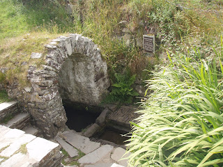
Despite (or perhaps because of) its remoteness, St. David’s seems to have been something of a hub for Celtic Christianity. St. David was born here, of course. His mother, St. Non, gave birth to him on a hillside to the south of the city, in the middle of a violent thunderstorm. A holy well and a ruined chapel mark the spot.


She then went on to Cornwall to found the church of Altarnun on the edge of Bodmin Moor, which is otherwise distinguished by being the home of the Western Morning News’ estimable farming editor, Peter ‘Bingo’ Hall, before heading off for more missionary work in Brittany.

On the other side of the city, close to the handsome beach of Whitesands Bay, a stone plaque indicates the site of what was once a

St. Non's well - created when a bolt of lightning struck the ground whilst she was giving birth to St. David. Must have been an electrifying experience!


chapel dedicated to St. Patrick, to mark the spot where the Welshman who was to become the patron saint of Ireland, set off from his native land. If you are looking for evidence of the links that joined the Celtic cultures in the centuries before the Conquest, there is no shortage of it in and around St. David’s.

I’ve got to know St. David’s reasonably well over the last few years, in my role as a director of Farms for City Children. Treginnis Isaf, on the very tip of the peninsula, looking across to Ramsey Island, is the second of the three farms that Clare and Michael Morpurgo set up to take residential visits from inner city primary school-children. I visited on Thursday morning and was delighted to learn from Mike Plant, the farm school manager, that the enterprise is going from strength to strength. A party of 40 or so ten year olds from Dartford in Kent were in residence and had just finished the morning mucking out of goats and pigs. A happier, more polite, genuinely interested and talkative bunch of school kids you never met in all your life.

All this, and a golf course too. The City of St. David’s GC celebrated its centenary five years ago and I doubt if it has changed much in all that time. It was ferociously windy, but the views of over Whitesands to St.David’s head on one side of the bay and Ramsey island on the other, were stunning.


Still no surfing. The sea was far too wild, even for the professionals, let alone for ageing wallowers like me. I was planning to head off to the Gower to try my luck there, but the forecast spoke of unrelenting rain, so I decided to cut my losses and take a few days off at home. Next stop is Cornwall, somewhere near Tintagel, on July 6. Catch you then, and in the meantime, I'll add some pics.


Carn Llidi and Whitesands Bay from St. David's Head

Tuesday, 24 June 2008

June 24 Talyllyn Ho!

On Sunday, after a storm-tossed night, I made a cautious way through the shrieking gale from Aberdaron to Tywyn. Quite why I picked Twyn, which is a rather wind-blown, sand-blasted seaside town with nothing in particular to recommend it (a bit like Seaton, but without the charm), for an overnight stop, I cannot now remember. The choice of “Hendy”, out of the dozen or so certificated locations in the Caravan Club directory, was a matter of pure chance. I did wonder vaguely whether “Mrs. A Lloyd Jones” might possibly be connected with John Lloyd Jones, whom I have known and respected for many years as one of the most intelligent and forward-thinking leaders of Welsh farming, but given that there must be thousands of Lloyd Jones in the Principality, I swiftly discounted it.
Carmen at Hendy

But it was that Lloyd Jones, sure enough. I arrived shortly after Sunday lunchtime and was immediately sat down and invited to share a bottle of good red wine with my hosts. We talked of mutual NFU friends, exchanged gossip and discovered a shared frustration with what is happening to the various schemes that have been developed to enable farmers to produce countryside as well as food. John has been Chairman for many years of CCW, the Welsh conservation agency which produced Tyr Gofal, hailed by the former Agriculture Commissioner, Franz Fischler, as “the most successful agri-environment scheme in the Europe”. Tyr Gofal has been taken over and ruined by the Welsh Assembly Government, in much the same way as the equally successful ESA scheme is being butchered by Defra to make way for its half-baked “Environmental Stewardship” in England.

In both cases, 20 years of painstaking progress, involving millions of pounds of taxpayers’ money, is likely to be chucked away because the conservation bureaucrats who presently call the tune in Defra cannot see beyond the end of their noses. You need pragmatism to find the right balance between food production and conservation. Natural England doesn’t appear to know the meaning of the word.

As with many another Welsh farm, tourism is very much the mainstay of Hendy’s income. It involves some handsome self-catering cottages and farmhouse b and b as well as the campsite, and appeared to be very much Ann Lloyd Jones’ creation and responsibility; a business which she combines with being a sturdily independent member of Gwynedd county council.

Ann apart, Hendy’s greatest asset is the Talylln railway, which runs so close to the farm that it even as its own halt. It has the distinction of being the first line in Britain to be taken over and run by volunteers; it was the inspiration for W.S.Awdry’s Thomas the Tank Engine; and its appeal is universal. I shared a carriage on the Monday morning with an American family (who were also staying at Hendy) who had travelled all the way from Chicago for the thrill of a trip on the Talyllyn. The little trains chug and clank their way up the valley through some of the most magnificent scenery you’ll see anywhere (the Dolgoch Falls are a particular delight) and you can go up and down the line all day, getting off and on wherever you fancy, and all for just £12.
Dolgoth gorge

In the afternoon, I drove to Borth, another undistinguished seaside town, strung out along Cardigan Bay a few miles north of Aberystwyth and, like Tywyn, beset on either side by mobile homes. Borth has one saving grace, and that is its golf course: an old-fashioned out and back links which I have hugely enjoyed playing ever since I first visited, some 16 years ago. I found a decent campsite nearby and by this stage it had become the most beautiful sunny afternoon. I didn’t play very well, but the setting more than made up for that. As I hooked and three-putted my way back along the shore, the whole of Cardigan Bay was laid out before me, from the Lleyn in the North, to Cardigan Island in the south.

The only thing missing was some decent surf. That has been the one big disappointment of the trip so far. When I was in Scotland and for most of the time in Ireland, the wind was from the east. Then, when it did switch to the South West, it was so violent, it blew out any swell. I’m now at Whitesands Bay, a mile of so from St. David’s, and I’ve got high surfing hopes for tomorrow.

Sunday, 22 June 2008


June 21 Land of my great-grandfathers.

I am two miles south-west of Aberdaron, at Tá»· Newydd on the very tip of the beautiful Lleyn peninsula. If it wasn’t for the driving rain and thick fog, I would be able to see Bardsey Island out of Carmen’s back window. The famously nationalistic and unremittingly gloomy Welsh poet, R.S Thomas, was parish priest here for 20 years. Almost everyone speaks Welsh. I am, in fact, so deep into Wales that I’ve almost come out the other side.
Typical Welsh weather

My son George likes to refer to this expedition, a touch sarcastically, as my “voyage of self-discovery”, and in one respect at least, that is exactly what it has proved to be. I wrote not long ago that “there isn’t a single drop of farming blood coursing through my veins”. It appears that I was wrong. Yesterday, after catching the early ferry from Dublin to Holyhead, I stopped off at Llandudno, to visit the only relations on my mother’s side of the family – the Welsh side – with whom we have any contact: my second cousin Mary Machin, and her husband Stephen. Mary’s mother Lyn was the daughter of my grandfather Daniel’s eldest brother, William, and before she died she made a start on piecing together a family tree.

From this, I discovered that the great-grandfather that Mary and I have in common – William Thomas – came from Ty’n y Clwt Farm, in Anglesey. Yes, farm! I don’t know any more than that about him, but on the face of it, he would appear either to have been a farmer, or at the very least to have been a farmer’s son. So far from there being not a single drop of farming blood in my veins, there could be as much as a whole pint! I shall view myself in a completely different light in future. Gibbo – descended from a long line of fiercely Welsh farmers. It probably explains a lot!

On Wednesday afternoon, I caught the bus from the campsite at Camac Valley into Dublin. I’m not a great fan of cities, but it has to be admitted that this is a handsome one. I followed the established tourist trail, through Temple Bar, and up O’Connell Street past the Spike to the Post Office, which featured so prominently in the Easter Rising of 1916. I even tracked down the bronze sculpture of Molly Malone in Grafton Street – “The Tart with the Cart”, as it is known, and with good reason. She’s showing more bosom than you could shake a stick at!
The tart with the cart!

I was just wandering back toward the bus stop, reflecting sadly on the deep irony that a city so famous for its pubs should be so lacking in decent beer, when I spotted “The Porterhouse Brewery”, in Parliament Street. I ventured in, and you’ll never guess what I spied on the bar? Yes, a handpump, dispensing 100% genuine real Irish bitter, called Sticklebracht, and brewed on the premises. It was excellent, and it is a lovely pub as well. If you’re ever in Dublin, don’t miss it.

The 200 mile drive from Caheersiveen to Dublin had been surprisingly uneventful, given the inherent dangers associated with Irish major roads, and their crazy run-off areas or whatever it is they’re called. You never know what you’re going to encounter in them – a brace of female power walkers perhaps (power-walking is big in Ireland), or maybe a pony and trap, a gaggle of cyclists, or even a family having a picnic. Yet none of this stops the heavy lorries from pulling onto these hard shoulders at high speed to allow following traffic to overtake. Whenever you cross a county boundary on a main road in Ireland, you’re confronted with a large sign warning of how many motorists have been killed on the roads there in the last year. I’m not in the least bit surprised. At one point, the lorry in front had to veer out of the hard shoulder to avoid a tractor and muck-spreader parked on it just over the brow of a hill. It could have been very nasty.

I’m also intrigued by the way the Irish write their warning signs on the road itself. If you read from the top down (which I guess most of us in England do), the wording appears as:

TAKING
OVER
NO
When I first saw it, I thought it was something to do with the Referendum campaign.

I also liked the one on the jetty at Doolin, where the ferries leave for Arran:

OF
PIER
END

Mind you, one of the most striking examples of Irishness I have encountered was here in Wales last evening. There isn’t even the ghost of a mobile signal here on the campsite (which is why this won’t be posted until Sunday). The only spot for miles around where there is some reception is about a mile down the road – right alongside the BT telephone box!
Bardsey Island, through the storm

Wednesday, 18 June 2008


June 18 Mannix depression


Storm brewing

Weather systems are well-named. ‘Highs’ and ‘Lows’ describe precisely the emotions inspired by their respective arrivals, whilst ‘Deep Depression’ speaks for itself. The one that enveloped Carmen and me at Mannix Point, at the bottom end of the Iveragh peninsula, had a peculiarly Celtic intensity, both in its nature, and its effect.


It left me particularly downcast, because it meant that no boats were sailing, and so denied me my one chance, on this trip, of visiting one of the most spectacular of all Celtic sites, the Skelligs, twin pinnacles of rock which jut out of the Atlantic, 12 miles or so out to sea from Waterville. I have a photograph of them on my bedroom wall at home, taken with a long lens when Claire and I visited Kerry in 2004. On the larger of the two – Skellig Michael – one of the most remarkable monasteries in the world was somehow constructed in the 7th century. It was abandoned some 500 years later but is still, apparently, substantially complete. Perhaps next time.

The weather was so filthy that I didn’t venture out of the van until tea-time. Valentia island (another stalwart of ‘weather reports from coastal stations’) was completely obscured by rain and low cloud, even though it’s just across the bay. I resisted the temptation (just) of drinking myself into a state of Celtic oblivion, and busied myself with the computer, which eventually condescended to accept two photographs for this blog, although whether they turn out to be the only two, we shall discover shortly.

Anyway, when the downpour finally eased, I did my laundry (8 euros, would you believe!) and then headed off into town to buy a newspaper and something for my supper. By great good fortune, I spotted a fish shop, where the owner was filleting some small plaice - “fresh off the boat sorr”. I bought some and fried them in butter for my supper and they were quite the best thing I’ve eaten in the entire journey.

Spirits revived, I headed off on the bike to the little ferry that crosses from Rennard’s Point to Valentia. By this time, it was a simply glorious evening, the rain having washed the air clean, and the fuchsia hedges which are such a feature of the west of Ireland fairly blazed with colour as I pedalled along.

The campsite and its owner – who rejoices in the name of Mortimer Moriarty – have won numerous awards, and despite the extortionate cost of using a washing machine and tumble drier, one can see why. The situation is perfect – on the edge of Valentia Sound, looking directly across to the island – and the facilities manage to be both homespun (like a peat fire in the communal reading room) and comprehensive. Assuming that I do return for another crack at Skellig Michael, this is where I shall stay.

Tomorrow, it’s the long drive to Dublin, for a ferry to Holyhead early on Friday.
What a wonderful place Ireland would be, if it wasn’t for the weather!
Mannix point with the mountains of Kerry beyond

Over the edge: The Atlantic, from Dun Aengus, on Inishmore.

Monday, 16 June 2008

June 16. On the edge

The Firbolg were an ancient Celtic race – possibly related to the Belgae - who colonised Ireland sometime around 1000 BC. According to one version of events (and ancient Irish history always owes as much to legend as to record), they were driven from the main island by invading Picts from Scotland, and made their last stand on the Aran Islands, in Galway Bay. There they left behind them a series of “Duns” – circular or semi-circular forts consisting of massive limestone ramparts – the most famous of which is Dun Aengus on the largest of the Aran islands, Inishmore.

Claire and I visited it on a gloriously sunny day on Saturday, and it is indeed a remarkable feat of primitive construction. But also, it struck me, a pretty pointless one. The site of the fort commands no harbour, or river crossing, or settlement. It has been built on the very edge of a 300 foot cliff. There is no water supply and the ground is solid rock. It is the sort of place you might build for your last stand, because, once invested by a besieging enemy, there would be no way out except that sheer drop into the Atlantic. No-one knows if that was indeed the eventual fate of the Firbolg, but they do seem to have disappeared rather abruptly – over the edge of history?

I am glad to say that despite the tens of thousands of people who visit the site each year, there is no safety fence on the fort’s seaward edge. The thing to do is to lie flat on your tummy and wriggle yourself up to the edge, so that you can hang your head over the edge of the limestone platform, and look down into the churning waters 300 feet below. It is a stomach-fluttering experience.

Much as Dun Aengus was the last bastion of the Firbolg, so the Aran Islands have long been regarded as the last bastion of true ‘Irishness’. The writer J.M. Synge (of “Playboy of the Western World” fame) spent many months there, attempting to learn Gaelic, around the turn of the 20th century, and has left a delightful account of his experiences, which I am reading.

It is, in truth, a wild and barren spot. The landscape of all three islands mostly consists of great sheets of limestone: a geologist’s delight, a farmer’s despair. On the highest point of Inishmore, next to the lighthouse, an old cottage has been furnished as it would have been in the old days, complete with earth floor, a peat roof and a bed of filthy rags. It looked all too horribly genuine.

Today, we’ve been to the Cliffs of Moher, where the Burren limestone pavement sheers off, as it meets the Atlantic. This is another place to be avoided by the vertiginous. Around the visitor centre (which has been dug into the hillside, like an enormous Hobbit’s house), there is a paved walkway, protected from the cliff edge by a barrier of limestone slabs. But after about 300 metres, that comes to an end, and from then on westwards, the way is along a narrow, rutted path, which must be hellishly slippery when it’s wet, with nothing between you and the Atlantic, 600 feet below. There is a sign, which rather plaintively implores visitors ‘please do not go past this point’, but it must be one of the most ignored signs in Ireland, and that’s saying something.

The cliffs are truly awe-inspiring. Even at 11 o’clock of a Monday morning, there were thousands of people there, most of them from America, by the sound of it, although there were also lots of Germans, French and even Russians. What is it about Ireland that attracts international tourists in such numbers, one wonders? After all, our beauty spots are just as spectacular (think the Scillies, St. Michael’s Mount, the Valley of the Rocks, Cheddar Gorge etc), and the weather’s better. So why don’t the Americans come? At least some of them must have had ancestors from the South-West, and especially from Cornwall.

Our food and drink is better as well. Continuing my search for a decent drop of beer, I’d tracked down a bar in Lahinch that was supposed to offer beers from the Biddy Early brewery. After a fruitless search, we discovered that it had changed its name, and when I asked the waitress if they had any local beers, she said no, “only the usuals”. How any country can claim to have a local food culture when the drinks it offers are either mass-produced (Guinness, Murphy’s, Smithwick’s etc), ersatz (Magners, Bulmers) or imported (the wine, most of it from Chile) is beyond me.

The truth of the matter is that, despite all of the hype, Ireland doesn’t have a local food culture. It has an international food culture, promulgated by celebrity chefs and tourism marketeers, which has been grafted on to the local cuisine, without changing in any way the underlying Irish taste for chips, stodge and fizzy beer. You should only come here for the food if you’ve got a very fat wallet, and even then don’t expect much that is genuinely local.

Having said all of that, Claire and I did eat very well, and reasonably, at the Riverside restaurant here in Doolin, last night. So it’s not all bad.


The three of us: Gibbo, Claire and Carmen at Nagle's Doolin campsite.

Friday, 13 June 2008


June 13 In St.Patrick’s footsteps

On Thursday, I climbed one of Ireland’s most famous mountains: Croagh Patrick, near Westport in County Mayo, known familiarly as “The Reek”. On its summit, Ireland’s patron saint spent 40 days fasting, praying and throwing the country’s entire population of snakes to their deaths, back in the year 441. It is a proper mountain, with a peak shaped like a rocket’s nose-cone, but at only 2,500 feet, I wasn’t expecting it to be too much of a challenge.
The Reek -an exhausting climb.......

How wrong can you be? It turned out to be by far the most exhausting climb I’ve ever made – far more difficult than Mount Brandon, Ireland’s second highest mountain, down in Dingle. The way up consists of a broad, deeply rutted, boulder-strewn avenue of scree, which becomes almost vertical on the final ascent to the summit. It was hard to say which was the more painful: the going up or the coming down. I’ve got two dodgy knees, and by the time I reached the bottom – with, Oh, such a heartfelt sigh of relief – I didn’t know which leg to limp on.

Yet this is a mountain climbed by hundreds of people every day, and by over 20,000 in a single day when Mass is celebrated on the summit, on the last Sunday in July. It must be the cause of more voluntarily embraced suffering than any other place in the British Isles. And for why? Because most of those who climb it aren’t merely tourists, they are pilgrims. This is a holy mountain, which attracts devout Catholics not just from all over Ireland, but from all over the world. I met one lady who was doing it barefoot, in honour of the Saint. She had painted the soles of her feet with tar, but even so, it must have been excruciating.

There is an Oratory on the summit. I reached it just as the clouds rolled in, blotting out what I’m sure would have been a spectacular view of Clew Bay and the mountains beyond. I’m afraid I didn’t walk around the chapel three times, saying my Hail Marys. My grandfather, a fiercely anti-Papist Baptist Minister, would never have forgiven me. But I did take myself off to a respectful distance before opening the can of Inch’s cider that I’d thoughtfully brought with me to celebrate the moment.


....with its due reward!

Then it was off through the mountains and lakes of Connemara to the Renvyle Peninsula. The landscape was strongly reminiscent of Scotland, but it somehow lacks the majesty - the grandeur - of the lochs and bens. The west of Ireland is rough, ragged, hairy-arsed country – a bit like the people who inhabit it. The village of Tully, where I stayed last night, has the most beautiful setting that could be imagined. It also has two of the most downright unpleasant “pubs” it has ever been my misfortune to visit. Both were populated by drunken, swearing locals. I don’t much like the F word in any circumstances, but it sounds particularly nasty and brutish, when delivered frequently and indiscriminately, almost as a punctuation mark, in a thick Irish accent.

That said, if there is one campsite that I would recommend to any reader planning a camping holiday in the West of Ireland, it is Renvyle Camping. The site leads directly onto a beautiful beach and offers the most wonderful panorama of mountains, from Slievemore, on Achill, through the Nephin Begg range in Mayo, past my old friend The Reek, to the Twelve Bens of Connemara, which were so forbidding that even St. Patrick gave them his blessing and passed on his way.


Now I have reached Doolin in County Clare, with the remarkable limestone pavement of The Burren behind me and the Cliffs of Moher in front. Clare is undoubtedly the place to be, with my wife Claire due to arrive from Shannon airport any minute. “Keep Clare Clean”, demanded a billboard as I crossed the county boundary. I shall do my best!

In the meantime, and reverting to the religious theme, I will leave you with a house in Doolin, which I guess must be owned by an ex-Catholic, who has seen the non- conformist light. It is called “Dunroman”!

PS – see previous comments on likely outcome and significance of referendums